Begin with the end in mind.
SINCE 1983.
Begin with the end in mind.
SINCE 1983.

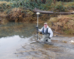


For the 270-acre Hayden Island which is located along the Willamette River downstream from Independence, Westlake first provided research and analysis of the record deed, existing survey information, and the Department of State Lands documentation, to determine the location and ownership of the slough. We prepared exhibit mapping for our client, and lastly, worked to finalize the boundary survey and write the legal descriptions for the property. Our survey included a detailed narrative of our findings regarding Department of State Lands documentation of the riparian boundary and Bureau of Land Management documentation, as well as physical evidence including recovered survey monuments and the observed location of the Ordinary High Water Line.
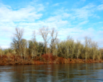
In 2016, the Gail Achterman Natural Area was formally created, honoring a well-known local conservationist. This property is made up of priority habitats, as identified by the Oregon Conservation Strategy, and is considered a significant riparian forest.
We were impressed by the quality of work and the deliverable schedule. Please pass on my appreciation to the project team. If you need a reference for future projects, I would be glad to give your firm one.”