Begin with the end in mind.
SINCE 1983.
Begin with the end in mind.
SINCE 1983.


Westlake has utilized 3D laser scanning to augment traditional topographic surveying for many intersections and roadways around the Portland metro area.
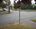
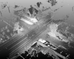
For the intersection of NE Klickitat St. and NE 57th Ave. in Portland, Oregon, Westlake Consultants used 3D laser scanning to illustrate the speed and depth of topographic and as-built data collected. 3D scanning allowed for remote data collection which minimized safety issues for the survey crew, pedestrians and drivers, and also reduced impacts to traffic. Scanning for data collection at intersections captures data which is far more detailed than conventional survey data. This laser scan data can be used to generate either 2D or 3D CAD drawings and because it is so visual, it supports public involvement program exhibits, and can be revisited to validate design and construction assumptions throughout the life of the project. Scan data is typically merged with conventional survey data to create composite topographic mapping.
I have worked with Westlake Engineering on numerous projects over the last 12 years and would recommend Westlake without reservation for any project requiring engineering, planning, or surveying services.”