Begin with the end in mind.
SINCE 1983.
Begin with the end in mind.
SINCE 1983.

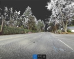

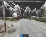


The Country Club Road Improvement Project provided a good opportunity for Westlake to utilize our 3D laser scanning capabilities to augment conventional topographic surveying and mapping. This intersection, nicknamed ‘Six Corners’, brings together Boones Ferry Rd., Country Club Rd, C Ave., Bayberry Rd., and two segments of Iron Mountain Rd. Both Boones Ferry Rd. and Country Club Rd. are designated ‘major arterials’ by the City of Lake Oswego, and the average daily volume of traffic through the corridor is 23,00 vehicles. By laser scanning sections of the project, we collected survey data quickly and minimized safety and accessibility concerns. Use of scanning provided a reduction in the number of necessary lane closures for traffic flagging, and decreased traffic disruption.
A total of 90 scans were captured (45 down each side of the road) during the mid-morning/afternoon. The scan images included here shows cars/traffic removed from the data – an advantage of scanning. The scanner “sees” 365 degrees, allowing it to capture data for elements that may not be part of the initial project scope but which often proves useful for designers. For example, the power lines seen in the scan image are a good example of out-of-scope data captured, and which can later prove useful.
Westlake functioned as a subconsultant to Murraysmith for the City of Lake Oswego to achieve the overall project goals of pavement rehabilitation, realignment and upgrade of a sewer main, stormwater updates, and replacement/upsizing of the water line to add fire protection.
I wanted to pass along a note of thanks for all the help Westlake has provided to us on our projects. The information your group produces is responsive, accurate and top notch work.”